
RIDES: First 4,000ft climb
Montagne De Lure.
"Montagne de what? Never heard of it?" I hear you say dear reader. Neither had I until I did one of my down-the-rabbithole sessions on Google Maps. You see, we were going on a family holiday to Provence, the the bike was coming along, so I was having a peruse of the local cycling potential. For me, Google Maps and its 3D option is the go-to piece of software for finding out about a hill in all its topographic glory. It gives a sense of realistic scale and of course, you can launch into countless streetview images to see it in reality. Anyway, I digress.... when we booked to go to Provence I was straight onto the web to find out as much as I could about mountain climbs near our chalet in Greoux-Les-Bains. Mont Ventoux was the obvious one - who doesn't want to do Ventoux? - but we were to be staying a bit further southeast, so although I was desperate to give it a go, a 2.5hr morning drive to spend the best part of three hours going up and down a mountain (even if it was the Giant Of Provence) seemed unreasonable on the family.
I had to look closer to home or suffer a bollocking of epic proportions from the other half.
Thankfully, when you go in 3D mode you can see far-off peaks that draw your attention and when you look at Ventoux (1909,m), if you draw a straight line east there is a series of lumps and bumps, a ridgeline of sorts, that ends with Montagne De Lure (1826m) and the similarities are striking; looking apparently snow-capped thanks to an exposed limestone peak, it's impressive in its prominence to everything around it, and offering over 4,000ft of climbing from its base, Montagne De Lure (or Signal De Lure as its official peak is named) would be a damn good stand in.
 |
| On Google Maps, Montagne de Lure looks like something out of a fantasy book. |
Looking back through the history of the mountain and its most notable cycling palmeres is it featured in two editions of Paris-Nice. For a big old climb I was surprised to find it's never featured in the Tour; it has all the hallmarks of at least a mid-stage epic climb, but I suppose when you have Ventoux within sight with its 5,300ft of climbing, you're always going to be the bridesmaid? On a good day you can apparently actually see Ventoux from the top and thanks to some visual similarities, it's acknowledged by some that the mountain is a kind of sister to its more famous sibling some 50km away.
On a map Montagne De Lure a fascinating mountain and the reason why I first happened upon it; think of those shell-like unpronounceable Belgian chocolates you get at Christmas, it's like one of those. Or is it an ear? Or maybe a seahorse lying face-down? Anyway, it's a weird shape, looking like it should have hosted a glacier at one point in time. The steep inner face curves around to create a protected valley at its base like the valley time forgot. Think Jurassic park in Provence and you might not be too far wrong! Plus, like Ventoux, on top is a weather station that points to its exposure to the elements and a crown of exposed limestone gravel gives an added sense of epicness from any angle you approach it.
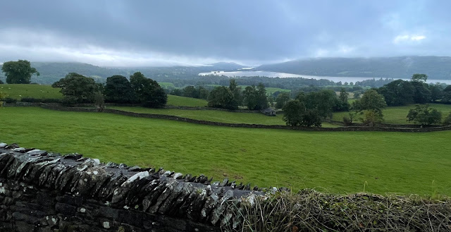
 |
| Montagne De Lure looking snow-capped in the distance. |
There are two ways up the mountain; from the south you head from Saint-Étienne-les-Orgues and past the ski station that sits just below the summit. This looks to be a lovely alpine-style climb through trees with a whole host of individual sections broken up by sweeping bends. However, I had my sights set on the approach from the north, which on paper is easier at an average of 5% as opposed to 5.9% on the other side, but also has more height gain (about 500ft more) and a more broken, unrhythmic structure. As you turn off the main road from Sisteron, the climb starts immediately, signified by a signs that tells you if the road is open or not. I assume this is for winter when snow comes to the region, although I recall one sign saying there was a closed roads day just for cyclists. The road meanders through tiny hamlets, always going up but not at any particularly alarming gradient. Where this is a relatively soft start, early morning quietness combined with total isolation really messes with your head because there's much of the climb that is shrouded in dense forest, a proper alone-in-the-wilderness climb. Look on Google maps for photospheres and you're out of luck - no one has been here to explore. Or maybe they have but they just didn't make it back?...
 |
| Open for business! I've read that it is also closed to traffic some days of the year - cycling heaven! |
I'd driven the 45 minutes up the autoroute from the place we were staying so by the time I'd parked up and started cycling, it was about 8am; still very sleepy in deepest Provence on a Sunday so as to be expected, there was no one around. A mile or so into the climb there was one point where I passed a farm and what can only described as the angriest rottweiler ever came rushing towards me, only to be halted 20 metres away by a chain that I was hoping was in tip-top condition. The thought of that breaking free and having a go at my ankles certainly put a few more watts through the pedals for sure! But other than that, I can't recall seeing anything or anyone else until the top. It's an eerie place in the shade of a mountain, the sound of the forest as animals break twigs and pine cones fall down the slopes above you. The road surface on this climb is decent, aside from odd patches where rain has washed slivers of white gravel across the road. Safety barriers are few and far between. It reminds you that even when you're going just a few miles per hour, you're screwed out here if anything goes wrong; take care going up, take even more care going down.
Like all mountainous roads in France that are popular with cyclists, kilometre markers are present all the way up the climb, telling you altitude, distance from the top and the gradient for the next 1000 metres. personally, I love this, not because it's helpful to pace yourself, but because you know you're in a country where this is important. We'd never do this on a large scale in the UK, cycling just isn't enough of a thing. We're lucky to get a good road surface!
 |
| The first 10-miles is spent navigating through thick forest, it really feels like the wilderness. |
I continue to tap out a humble pace as the grey squiggle of tarmac winds its way skywards through forest that, in the late August morning, is getting muggier and more oppressive. We'd had temperatures of over 35˚C throughout our holiday and today was looking to be no different. The Garmin was saying 16˚C when I started but by 9am I swear it was British summer time temperatures. Maybe that's the age-old thing when you're climbing, you get super-hot regardless of fluid intake? I've had worse but it all adds to the experience and the uncertainty of how you're doing on a climb that's totally unknown to you.
The climb in its entirety is over 16 miles long, with the flatter, 'squiggly bit' being a good 10 miles in length. Over this part you make up over 2,000ft of climbing without fully realising it; because it's not all hairpins you just keep pedalling and although you see the roadside markers telling you you're going up, I found myself just drifting off, zoning out. I love cycling because of its ability to help clear my head, climbs are no different. In fact, they're probably where you brain can be at its emptiest as you focus on just turning the pedals. Of course, it can easily go the other way on a climb and once you get something in your head it's hard to shake it - the earworm of thoughts. Thankfully, aside from hoping raging doggie wasn't going to be angry on my return down the mountain - this was to be an up-and-down, I was on a strict time so no big loops today - my mind was clear of any thoughts, I was in full holiday, chill-out mode.
 |
| Looking north towards the Alps... if only an iPhone could capture the level of detail the eye sees. |
Once that first 10 mile stretch was done, that's when the first of four big hairpins happen. Each corner offers up the start of a steeper ramp where it helps to bring the average gradient up; we're not talking super-steep ridiculous stuff but 7-10% is enough to put some burn in the legs. Between each corner it's about 1.5 miles, so a significant chunk of climbing and it's at this point when you start to get glimpses of the countryside below through the trees. Morning haze softens the far-off peaks of the Alps beyond the town of Gap, creating layer-upon-layer of muted greens and browns that an iPhone camera struggles to convey.
Once you've done the three ramps, you get to Pas de la Graille (1597m), which is the col that gives passage over the mountain. There's a nice viewing area up here and a small car park, but it's not the actual summit. Nonetheless, seeing both north and south from one point reinforces that you're in mountainous terrain for real, proper cycling territory. From here the road surface surprisingly goes a bit awry; smoothish tarmac blends into stretches of rougher chipseal that despite the gradient hovering around 3%, makes things a bit of a drag. Still, by this point you can see the weather station and that brings visions of Le Tour at the summit of Ventoux, if only for a moment until you realise this isn't exactly the same. This last two miles is fully exposed and thankfully, there's a cooling breeze that doesn't hamper progress but makes things much more comfortable.
 |
| On a clear day you can see Mt Ventoux from the top. Not today though... |
The summit isn't much to talk about to be honest, not that I was expected it to be a topping-out ceremony on Everest or anything. There's a large gravelled area, a rudimentary car park, a steel sign and some tourist info about what you can see. The weather station is up a gravel track, one for the mountain bikers really, so once a few photos are done and after I've searched in vain for a sight of Mont Ventoux through the haze, it's time to hot-foot it back down to the car and back to the family before lunchtime. It's 10am at this point and aside from a couple in a car at the top, the only other cyclist I see is one coming up from the direction I ascended; I later looked on the Strava flyby and saw he'd completed a 70-mile loop that day, with his ascent taking 20 minutes less than my 1hr 44m. As a tourist, I'm happy with that time to be honest.
 |
| Exposed to the elements, limestone gravel everywhere, a weather station... it's like a mini Mont Ventoux. |
I'd not really put 2+2 together when it came to the descent; I obviously knew it was 16 miles up so therefore 16 miles down. However, descending hills always seems like it goes in a flash - UK hills anyway - but this took absolutely ages, 50 minutes to be more or less exact! I'll put it out there that I'm no descender. A combination of being heavy (85kg at the time) and running 140mm rotors, plus having an extreme fear factor, means I was probably on the brakes a little too much. But it's still a long way to go, 16 miles is, and going at breakneck speed means your hands turn into claws as you pump the brakes... not for me thank you. I dialled it back, enjoyed the ride down and watched out for the odd car that you can't really hear when the wind is rushing over your lugholes. And no crazy doggie waiting for me.
A short, flat section after the bottom of the climb and I was back at the car, absolutely buzzing; I'd done my first massive climb. I said this is a 4,000-footer and it is... just. If you go by the main Strava segment comes out at 4,015ft, so like they say, "if it's not on Strava it didn't happen..." and this was well and truly recorded for posterity. The first of many hopefully.
Here are some useful resources for the mountain in general:
Comments
Post a Comment